Updated 6/14/2018 2:27pm HST, originally published 6/9/2018
I intended the next post to be about searching for a home on Oahu. But the media is obsessed with Kilauea. Ignore the news media. Except they keep making us sound like we are all going to die...
Folks on Hawaii Island are having a hard time. If you haven't heard, Kilauea on Hawaii continues to erupt, the most recent eruption actually began in 1983, the location of the fissures and the flow are somewhat new. One fissure is fountaining lava, which produces Pele's hair (lovely wafting glass filaments that are murder on human tissue) and gases, and lava. Once the lava flow hits the ocean it produces
laze, which is very dangerous to anyone in the immediate vicinity. Therefore
Hawaii County Civil Defense is keeping everyone out of the immediate vicinity.
But Kilauea is not Mt. St. Helens, people. Mt. St. Helens is part of the Ring of Fire, with a different amount of silica in it's magma/lava, leading to much more violent eruptions and other issues we don't really have.
 |
| Hawaii is under the F of fire. Retired in Samara, where I found the map, provides a perspective on island life on the other side of the Pacific in the Ring of Fire, with a different set of volcanic and weather concerns. |
 |
| Borrowed from Cornell, Hawaii is the red dots in the upper middle of thePacific in the left of the image. The lines of earthquakes mark out the edges of the tectonic plates. Note the dots or "hotspots" in the Pacific Ocean, including Hawaii. We're not on the edge of a tectonic plate, we're in the middle of a tectonic plate, which makes our geology different, including the consistency of our lava. |
Hawaii's lava flows are generally the consistency of honey, a bit viscous but freely flowing. The Ring of Fire volcanoes flow more like peanut butter. There is flow, but very little, very slowly, and when gases get trapped, they build up and explosions are much more likely.
How the Earth Was Made: Ring of Fire, 2010, currently available on Amazon Prime is very informative. Simply, Hawaii's volcanos are much less likely to explode, and when they do explode it is less of an explosion with a smaller footprint, more like breaking to the surface and flowing across it than causing the surface to go flying in all directions for miles. Update: MidWeek Oahu's Bob Jones wrote a summary in the
June 13, 2018 edition, p.8, of some interesting theories explaining the increased volcanic activity the world seems to have seen recently and a nice graphic of the layout of Kilauea underground explaining the currently active East Rift Zone. He also goes into some detail on the difference between the hot spot source of Hawaii volcanos and the tectonic plate interactions that are the source of the Ring of Fire volcanos.
So if you have travel arranged to Hawaii, please go and support the local economy, just make sure you subscribe to the USGS and Hawaii County Civil Defense updates described below. And stay out of the parts you are told to stay out of. If you plan to visit the other islands, they also have individual notification services and phone apps to which you may want to subscribe.
How hard is it to link to
USGS Volcano Notification System and
Hawaii County Civil Defense updates? Easy peasy. I receive them by email,
Twitter and
Facebook feed (on the USGS facebook page click the SUBSCRIBE link on the upper right). They publish helpful
maps like the one below on a daily basis to Twitter and Facebook and provide text emails with hyperlinks to every mapping product imaginable. USGS also models
potential areas of ashfall, as well as collecting
Citizen Scientists' data on ashfall, including when it does not fall, as well as
samples of ash that does fall (complete with a
data sheet). The model used was developed for Alaska volcanos and not directly applicable to Hawaii volcanos, therefore the citizen scientist observations are used, along with USGS observations, to adapt the model for use in Hawaii. Y'all know what I'll be doing on my eventual trip to Hawaii Island (yay! data!)
USGS Hawaii Volcano Observatory produces really nice explanations and graphics about everything volcanoes related, including the
gaseous dangers from Hawaii's volcanoes and the conditions under which state residents may be affected:
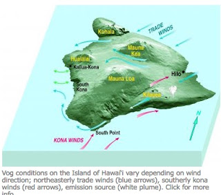 |
| Note Kilauea is on the southeast of Hawaii, farthest east of the Hawaiian Island chain. |
Life on the other islands is affected by the volcano if the wind shifts.
Vog may cause respiratory problems and there may be changes to flight patterns. Currently, according to the live wind map reproduced below, we have Trade Winds blowing east to west, but we were
forecast to have southeasterly Kona winds Friday night through today, leading to possibility of vog on Oahu. It is muggy and still in our backyard right now and we gave in and ran the AC because we could not get the air to move through the house. The occasional whiff of breeze is coming from the Trade Winds direction and we seem to be vog-free.
 |
Live Earth wind flow at 2:28 HST 6/9/2018 from https://earth.nullschool.net/#current/wind/surface/level/orthographic=-156.97,20.54,3000/loc=-158.000,21.492
This live image layer of wind flow is used by the local Hawaii TV stations as a map-base when they talk about our weather. Oahu is under the green circle. Currently we have Trade Winds, blowing east to west. |
Next post will probably be about home design with consideration for how to capture those Trade Winds we currently find so elusive, and what to do about hurricane season, tsunamis, kona cyclones, and earthquakes. I am subscribed to City and County of Honolulu's smartphone
App for emergency and other alerts. The NO TSUNAMI un-warnings/reassurances/non-alerts(?) are almost constant right now in response to the very frequent magnitude 5+ earthquakes from Kilauea's vicinity...


Comments
Post a Comment